

Cambridgeshire villages put their best foot forward helping RSPB Ouse Fen launch new trail maps to the reserve

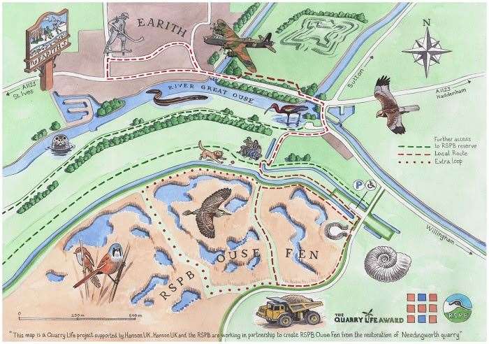
New trail maps highlighting how easy it is to walk from four Cambridgeshire villages to RSPB Ouse Fen have just launched.
They are the result of a nine-month collaborative effort between the RSPB, Hanson UK and communities in villages surrounding the nature reserve.
Residents from Earith, Bluntisham, Over and Needingworth took part in workshops to help advise and guide the design of the four trail maps, which cover public access routes that lead to RSPB Ouse Fen. Local knowledge provided by residents helped in the designs, including pinpointing well known landmarks to feature along the routes.
The workshop groups provided ideas about what they would like to see at the end of each walk where the trail meets RSPB Ouse Fen, and a combination of benches, birdboxes and habitat improvement works were suggested. With hands-on help from local residents, the habitat work was completed and benches and birdboxes were installed.
These maps aim to encourage more local people to arrive on foot instead of by car at the nature reserve and recent guided walks using the new maps and looking at history and nature along the routes, were well attended by the local community.
This work was delivered by the RSPB and Hanson UK as the part of the Quarry Life Award project, with Hanson UK providing funding for the new maps and destination features. This work is part of the ongoing partnership project that is creating RSPB Ouse Fen.
Mapping these trails is part of the wider Hanson-RSPB Wetland Project, an ambitious project that started in 2001 and will run until 2030. Working together, Hanson UK and the RSPB are gradually turning Needingworth Quarry into the biggest reedbed in the UK covering 460 hectares (644 football pitches) and expanding RSPB Ouse Fen to 700 hectares (980 football pitches) of wildlife rich fenland habitat by project end.
In combination with neighbouring wetland reserves, Fen Drayton Lakes and the Ouse Washes, this wetland project will contribute towards the nearly 3,000 hectares of wider landscape scale wetland.
RSPB Project Officer Charlotte Mulderrig said: “We are really grateful to everyone who stepped forward to help us put these maps together. It has been a real collaborative effort and the local knowledge provided has proven invaluable in making these maps work.
“Walking and getting out into nature has proven physical and mental health benefits. Not only that but every trip we have in a car makes an impact on our carbon emissions, so we’re really pleased to raise awareness of these walks to RSPB Ouse Fen from nearby villages.
“Thank you again to all of those who took part, to the local Parish Councils who helped facilitate this opportunity and for the funding from Hanson UK. We look forward to seeing everyone at the nature reserve again really soon!”
Hilton Law, unit manager, Hanson UK, said: “We are extremely proud of our partnership project with the RSPB at Ouse Fen. It is a great example of how industry and the conservation sector can deliver sustainable projects for the benefit of the local economy, society and the environment.
“It highlights the benefits that managing the land left behind from mineral extraction can make in shaping and improving habitats for wildlife.”
RSPB Ouse Fen is a thriving wildlife haven with star bird species including bittern, marsh harrier, bearded tit, reed bunting, little egret and great crested grebe all calling the nature reserve home. It also includes a vast array of wetland habitat such as lakes, reedbed and fens.
The new trail maps can be found in the download section on: www.rspb.org.uk/ousefen